Current Projects
-
"Advancing Drought Monitoring Using a Small Unmanned Aerial Systems (UAS) for Conjunctive Water Management in a Changing Climate", FY16-Present
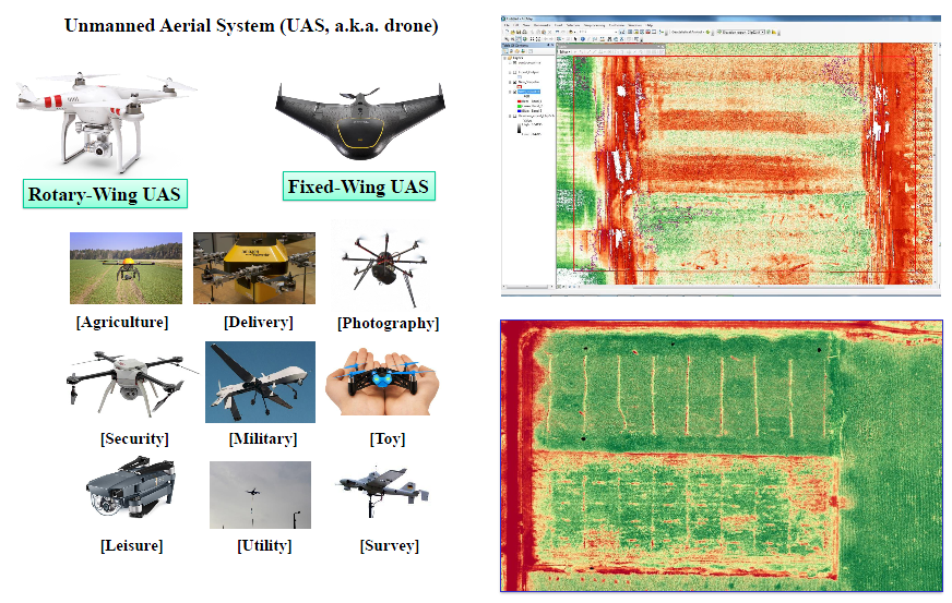 Climate variability, weather extremes and climate change continue to threaten the sustainability of water resources in the western United States. Given current climate change projections, increasing temperature is likely to modify the timing, form, and intensity of precipitation
events, which consequently affect regional and local hydrologic cycles. As a result, drought, water shortages, and subsequent water conflicts may become an increasing threat in monotone hydrologic systems in arid lands. In this study, we apply a small unmanned aerial systems (sUAS) to advance drought monitoring
and outlooks so that planners and end users can more effectively manage and meter out limited water resources. Images of Normalized difference vegetation index (NDVI) on the left represent how crops responde to different irrigation rate and various manure applications in the farm field.
Climate variability, weather extremes and climate change continue to threaten the sustainability of water resources in the western United States. Given current climate change projections, increasing temperature is likely to modify the timing, form, and intensity of precipitation
events, which consequently affect regional and local hydrologic cycles. As a result, drought, water shortages, and subsequent water conflicts may become an increasing threat in monotone hydrologic systems in arid lands. In this study, we apply a small unmanned aerial systems (sUAS) to advance drought monitoring
and outlooks so that planners and end users can more effectively manage and meter out limited water resources. Images of Normalized difference vegetation index (NDVI) on the left represent how crops responde to different irrigation rate and various manure applications in the farm field.
Investigators at UI: Jae Ryu
Relevant Publications/Products:*,# indicates graduate student and postdoctoral associate author, respectively
(1)Jae H. Ryu, Jungjin Kim*, 2016. Advancing Drought Monitoring using a Small Unmanned Aerial System (sUAS) for Conjunctive Water Management in a Changing Climate AGU Fall Meeting, 2016, American Geophysics Union (AGU) [download] -
"Impact Assessment of Urbanization and Land Use Change Using Low Impact Development (LID) to Characterize Water Quantity and Quality in the Boise River", FY14-FY16
 In recent years, urbanization and land use change are very active in the Boise areas due to economic development and population growth.
People are moving to Boise to pursue job opportunities in secondary and teritary industries as a result of increased agricultural productivity and also people are looking for better environmental and social living at the rural-urban interface.
Consequently, concerns of water resources management and nonpoint source (NPS) pollution control due to rapid growth often lead research agenda and policy making to mitigate impacts driven by urbanization.
The research aims to reduce potential flood risks and to mitigate water quality impacts using LID technologies, such as bioretention.
The bioretention options are incorporated into HSPF hydrological modelling framework to evaluate how LID can mitigate hydrological and environmental impacts induced by urbanization and land use change at the Boise River since 1992.
In recent years, urbanization and land use change are very active in the Boise areas due to economic development and population growth.
People are moving to Boise to pursue job opportunities in secondary and teritary industries as a result of increased agricultural productivity and also people are looking for better environmental and social living at the rural-urban interface.
Consequently, concerns of water resources management and nonpoint source (NPS) pollution control due to rapid growth often lead research agenda and policy making to mitigate impacts driven by urbanization.
The research aims to reduce potential flood risks and to mitigate water quality impacts using LID technologies, such as bioretention.
The bioretention options are incorporated into HSPF hydrological modelling framework to evaluate how LID can mitigate hydrological and environmental impacts induced by urbanization and land use change at the Boise River since 1992.
Investigators at UI: Jae Ryu
Relevant Publications/Products:*,# indicates graduate student and postdoctoral associate author, respectively
(1)Jae H. Ryu, Jungjin Kim*, 2014. Runoff and Nonpoint Source Control using LID for the Boise River Watershed, Idaho Advances in Flowing Waters, 12(1), American Water Resources Association (AWRA) [download] [Water Quality Conference Presentation] -
"NSF Idaho EPSCoR Research", FY10-13
- Streamflow Disaggregation from Monthly to Daily Value:
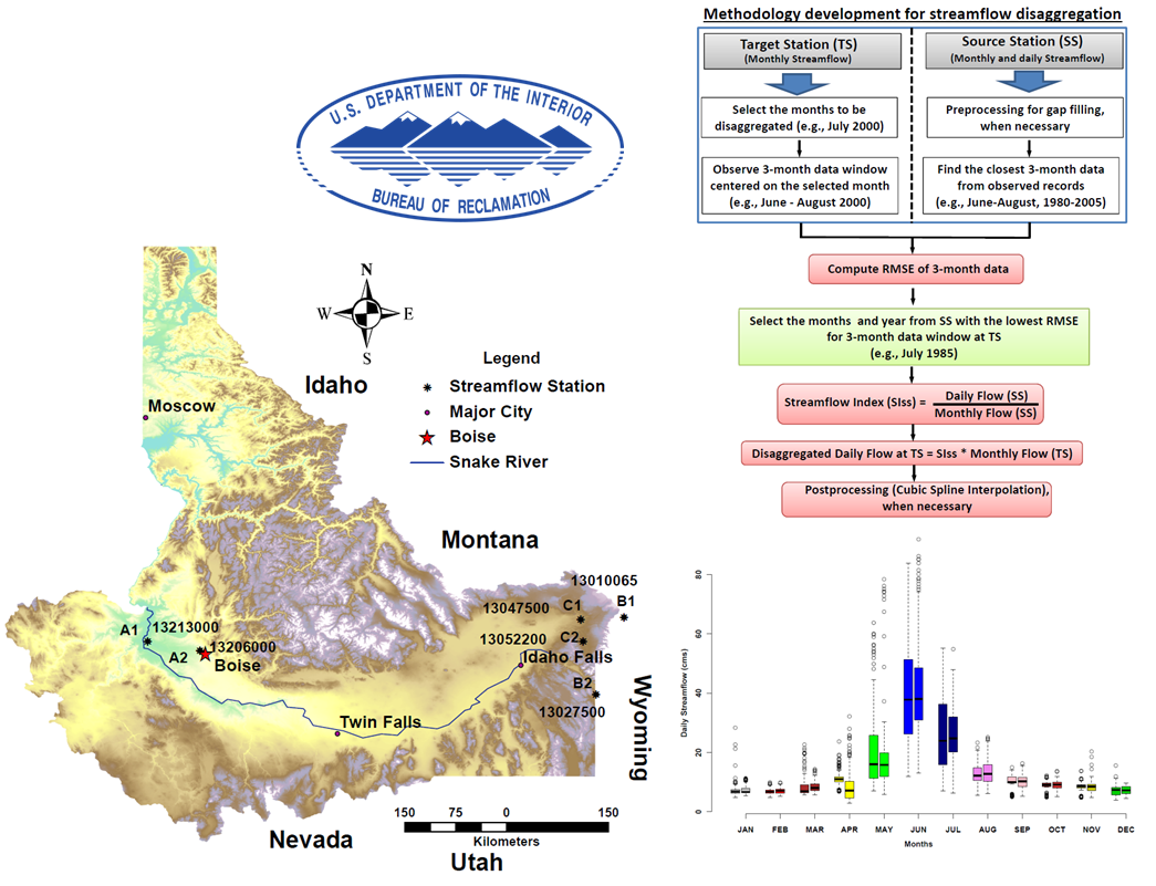 The tool developed in an Excel environment is fairly simple, broadly applicable with less computational burden, and provides a solution to the disaggregation problem which is of interest to many state and local agencies at present.
This tool can be applied directly at any site to conduct streamflow disaggregation beyond Idaho watersheds.
The tool developed in an Excel environment is fairly simple, broadly applicable with less computational burden, and provides a solution to the disaggregation problem which is of interest to many state and local agencies at present.
This tool can be applied directly at any site to conduct streamflow disaggregation beyond Idaho watersheds.
Investigators at UI: Jae Ryu
Funding Agency: National Science Foundation (NSF)
Relevant Publications/Products:*,# indicates graduate student and postdoctoral associate author, respectively
(1). Anil Acharya#, Jae H. Ryu, 2013. A simple method for streamflow disaggregation Journal of Hydrologic Engineering (in press), doi:10.1061/(ASCE)HE.1943-5584.0000818 [download]
(2). Anil Acharya#, Jae H. Ryu, 2012. Streamflow Disaggregation for Regulated and Unregulated Waterways In the 4th Annual Western Consortium Tri-State Meeting, Sun Valley Resort, Idaho, April 2-5, 2012 [Poster Presentation]
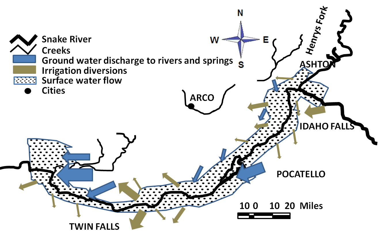
(3). UI's Disaggregation Software: [Software download]. This method is also implemented at Pisces, a federal government water database, in collaboration with scientists at the Bureau of Reclamation, Office of Pacific Northwest Region. - Development of Decision Support Tools for Sustainable Water Resources Planning and Management: A System Dyanmics (SD) was applied to address dynamically complex problems with management of the Eastern Snake Plain Aquifer (ESPA) system and associated surface-water and groundwater interactions. Recharge and discharge dynamics within the aquifer system are characterized in an environmental modeling setting to identify long-term behavior of aquifer responses to uncertain future climate variability. This research shows that the system dynamics is a promising modeling tool to develop sustainable water resources planning and management in a collaborative decision-making framework, such as Comprehensive Aquifer Management Plan (CAMP).
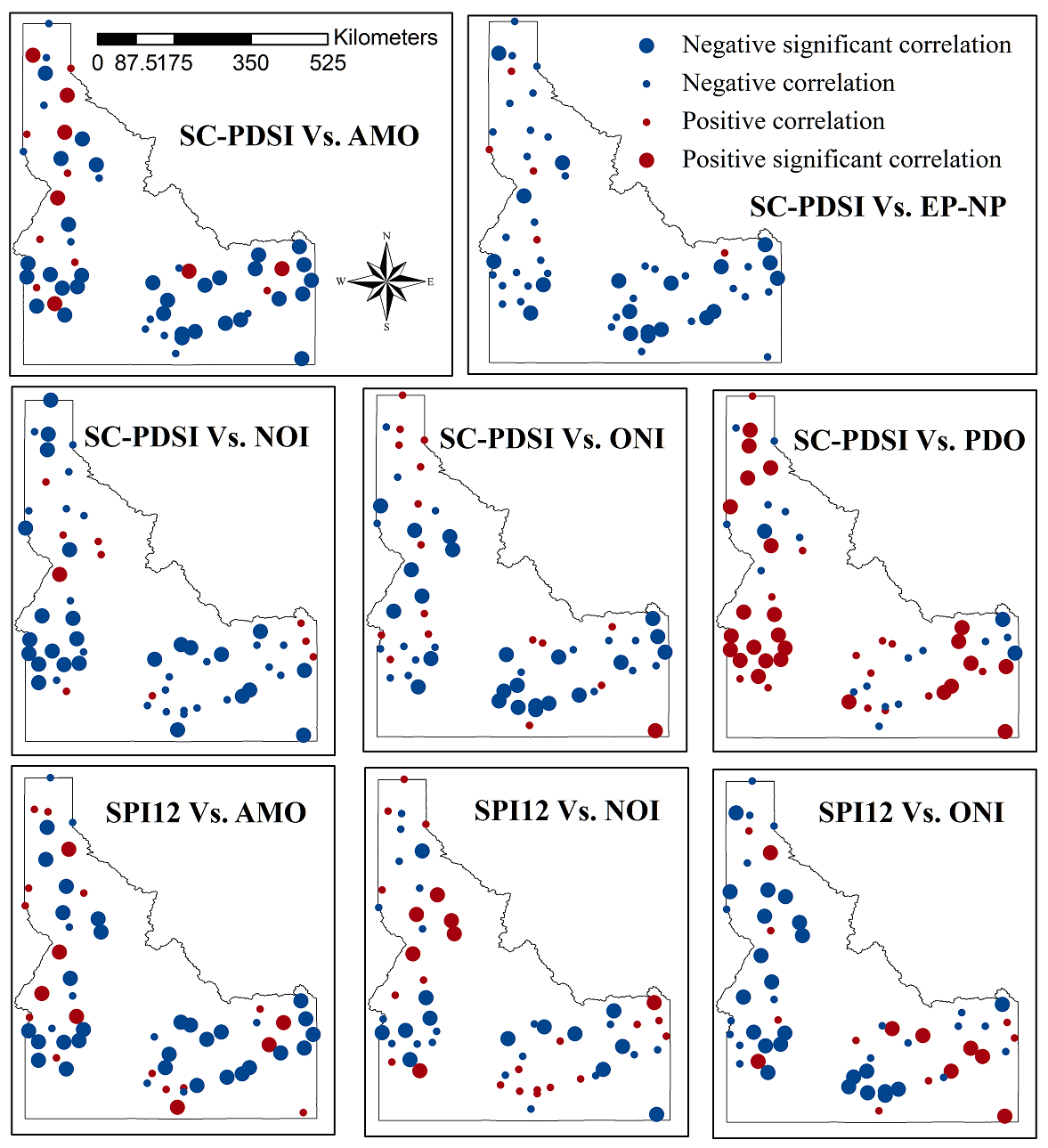
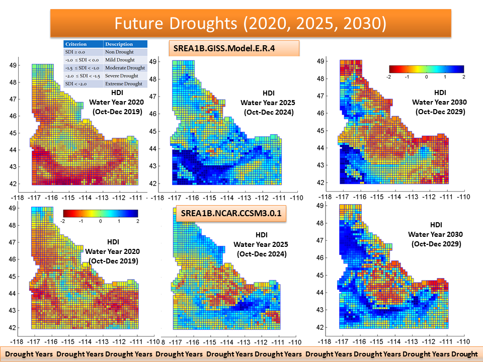
- Climate Extremes in the State of Idaho: Climate extreme and its linkage to regional drought has been investigated to identify consequences of climate variability on agricultural and regional water resource. Various climate and drought indices, including precipitation, mean temperature and maximum temperature, Palmer Drought Severity Index (PDSI) and Standardized Precipitation Index (SPI) are used to identify spatial and temporal distribution of climatic extreme and variability as well as drought frequency and magnitude. The result indicates that decreasing trends and increasing trends are identified for precipitation and temperature, respectively. Given current climate conditions, the result also implies that these trends will continue in the future possibly driven by uncertain climate variability. We anticipate that this research will contribute to drought-forecasting capability in this region.
- Toward mapping gridded drought indices to evaluate local drought in a rapidly changing global environment: Uncertain future climate, recent persistent droughts, and subsequent water conflicts increasingly threaten the sustainability of regional water resources around the world. Climate change and ongoing water disputes brought about by changes in water availability and timing emphasize the need for decision makers to develop proactive adaptive management strategies to mitigate losses. Developing a drought monitoring and management system equipped with advanced visualization settings is critical to lay out drought devolvement at local scales.
Investigators at UI: Jae Ryu
Funding Agency: National Science Foundation (NSF)
Relevant Publications/Products:*,# indicates graduate student and postdoctoral associate author, respectively
(1). David Hoekema*,Jae H. Ryu, 2013. Evaluating Economic Impacts of Water Conservation and Hydrological Forecasts in the Salmon Tract, Idaho
American Society of Agricultural and Biological Engineers, under review.
(2). Jae H. Ryu, B. Contor, G. Johnson, R. Allen, J. Tracy 2012. System Dynamics to Sustainable Water Resources Management in the Eastern Snake Plain Aquifer under Water Supply Uncertainty, Journal of the American Water Resources Association, 48(6), 1204-1220 [download]
 The tool developed in an Excel environment is fairly simple, broadly applicable with less computational burden, and provides a solution to the disaggregation problem which is of interest to many state and local agencies at present.
This tool can be applied directly at any site to conduct streamflow disaggregation beyond Idaho watersheds.
The tool developed in an Excel environment is fairly simple, broadly applicable with less computational burden, and provides a solution to the disaggregation problem which is of interest to many state and local agencies at present.
This tool can be applied directly at any site to conduct streamflow disaggregation beyond Idaho watersheds.
Investigators at UI: Jae Ryu
Funding Agency: National Science Foundation (NSF)
Relevant Publications/Products:*,# indicates graduate student and postdoctoral associate author, respectively
(1). Mohammad Sohrabi*,Jae H. Ryu, J. Abatzoglou, J. Tracy, 2013. Climate extreme and its linkage to regional drought over Idaho, USA
Natural Hazards, 65:653-681. [download]
(2). Mohammad Sohrabi*,Jae H. Ryu, J. Tracy, 2011. Trend Analysis of Weather Extremes in Idaho
AGU Fall meeting, Dec 5-9, San Francisco, California. [Poster download]
 Although much research on drought at national, regional, and local scales has been conducted to mitigate drought impacts, still drought claims economic losses estimated at about $8.5 billion per year.
One possible reason for such huge losses may be a lack of clear understanding of the characteristics of dorught at local scales that the end user can relate to the particular water management constraints of their basin.
This research aims to evaluate drought characteristics of tens to hundereds of thousands of interacting and diffusing water flows at high spatial resolution using big data, such as remotely sensed data and Unidata products by means of widely used drought indices.
Computer parallelism in high-performance computing (HPC) environment for drought analysis is being implemented in this research.
Although much research on drought at national, regional, and local scales has been conducted to mitigate drought impacts, still drought claims economic losses estimated at about $8.5 billion per year.
One possible reason for such huge losses may be a lack of clear understanding of the characteristics of dorught at local scales that the end user can relate to the particular water management constraints of their basin.
This research aims to evaluate drought characteristics of tens to hundereds of thousands of interacting and diffusing water flows at high spatial resolution using big data, such as remotely sensed data and Unidata products by means of widely used drought indices.
Computer parallelism in high-performance computing (HPC) environment for drought analysis is being implemented in this research.
Investigators at UI: Jae Ryu
Funding Agency: NSF Idaho EPSCoR Office
Relevant Publications/Products:*,# indicates graduate student and postdoctoral associate author, respectively
Jae H. Ryu, Mohammad Sohrabi*, Anil Acharaya#, 2013. Toward mapping gridded drought indices to evaluate local drought in a rapidly changing global environment:
Water Resources Management, under review.
This project is being conducted in collaboration with the research team in the civil and environmental engineering at University of Illinois-Urbana Champaign (UIUC). The goal of this project is to incorporate the latest state-of-the-art forecast tools in the Decision Support System (DSS) by indicating whether drought will strengthen or weaken as time goes on.
 Such information will help stakeholders, such as irrigation farmers and reservoir managers translate the drought prediction
into specific decision making processes.
Additionally, this enhanced DSS tools will provide real-time decision support information regarding "what to do now" and "what to wait and see."
Such information will help stakeholders, such as irrigation farmers and reservoir managers translate the drought prediction
into specific decision making processes.
Additionally, this enhanced DSS tools will provide real-time decision support information regarding "what to do now" and "what to wait and see."
Investigators at UIUC: Ximing Cai, Xin-Zhong Liang, Praveen Kumar
Investigators at UI: Jae Ryu
Investigators at UNL: Mark Svoboda, Cody Knutson, Meghan Sittler
Funding Agency: National Aeronautics and Space Administration (NASA)
Relevant Publications:*,# indicates graduate student and postdoctoral associate author, respectively
(1). Mohammad M. Sohrabi*,Jae H. Ryu, J. Abatzoglou, J. Tracy, 2013. Climate extreme and its linkage to regional drought over Idaho, USA, Natural Hazards, 65:653-681 [download]
(2). Jae H. Ryu, B. Contor, G. Johnson, R. Allen, J. Tracy 2012. System Dynamics to Sustainable Water Resources Management in the Eastern Snake Plain Aquifer under Water Supply Uncertainty, Journal of the American Water Resources Association, 48(6), 1204-1220 [download]
(3). Jae H. Ryu, M. Svoboda, J. Lenters, T. Tadesse, C. Knutson 2010. Potential extents for ENSO-driven hydrologic drought forecasts in the United States, Climatic Chnage, 101:575-597 [download]
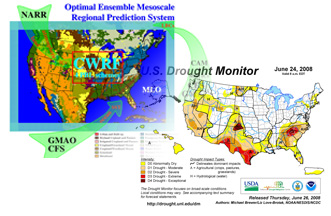
In January 2000, the Hydrology Laboratory (HL) of the National Oceanic and Atmospheric Administration/National Weather Service (NOAA/NWS) initiated the Distributed Model Intercomparison Project (DMIP) to improve river and streamflow forecasts associated with modeling systems based on Next Generation Data (NEXRAD) multi-sensor precipitation products. Results of the first phase (2000-2002) suggest that the spatial rainfall derived from NEXRAD, as opposed to point observations, can improve streamflow forecast in higher order of stream embedded basins.
This phase also provided a significant emphasis on the hydrologic modeling framework and compared the performances between existing distributed models and lumped models in terms of model formulation, parameterization, and levels of calibration. Based on key findings from DMIP, NOAA/NWS extended intercomparison work to a second phase of DMIP (DMIP2) to identify more critical modeling issues associated with computational requirements in an operational environment and forecasting setting.
As a one of participants, I had decided to utilize the Hydrological Simulation Program-Fortran (HSPF) model system in this study not only because it is a rainfall-runoff model linking surface dynamics to groundwater recharges through climate forcing data, but also it provides a wide range of flexibility for model formulation and calibration processes. Although participants were allowed to use any physically based rainfall-runoff models, the selected models should be able to meet a list of specific requirements of the NWS, such as capability of distributed modeling, adoptability of high-resolution data sets (e.g., NEXRAD), ability of ungaged streamflow simulation, and potential of streamflow forecast.
Investigators: Michael Smith et al.
Participants: Jae Ryu and many others
Funding Agency: National Oceanic and Atmospheric Administration (NOAA)
Relevant Publications:* indicates graduate student
(1). Jungjin Kim*, Jae H. Ryu, 2013. Basin discretization effects in HSPF simulations with NEXRAD inputs,
Journal of Hydrologic Engineering, under review.
(2). Jae H. Ryu, 2009. Application of HSPF to the Distributed Model Intercomparison Project: Case Study, Journal of Hydrologic Engineering, 14(8), 847-857 [download]
Completed Projects
-
"US Drought Atlas", FY07-10
US Drought Atlas has been initiated by the Institute for Water Resources (IWR). The main purpose of this project was to provide a unique source of information related to droughts, such as frequency, severity and duration as a function of Precipitation and streamflows. The Atlas can help stakeholders make short term tactics and long term strategies for water management and operational decisions. The research team in the National Drought Mitigation Center continues working this project by extending data records and enhancing visualization using GIS technology. Final deliverable would include an electrical version of static maps as well as online version of dynamic maps.Investigators: Donald Wilhite, Mark Sbovoda
Collaborators: Jae Ryu, Soren Scott, Jeff Nothwehr
Funding Agency: United States Department of Agriculture (USDA)
Relevant Publications:
Jae H. Ryu, M. Svoboda, J. Okalebo, 2009. Visualizing hydrologic drought information on the web using state-of-the-art geospatial mapping technology, ASCE World Environmental and Water Resources Congress, May 17-21, Kansas City, Missouri [download] [Presentation File]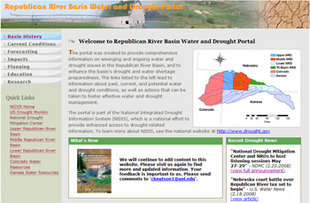
-
"Republican River Basin Water and Drought Portal", FY07-09
This portal will be a gateway to provide comprehensive information on water and drought issues in the Republican River Basin. Such information includes past, current, and potential water and drought conditions, as well as actions that can be taken to foster effective water and drought management. The portal is part of the National Integrated Drought Information System (NIDIS), which is a national effort to provide enhanced access to drought-related information. To learn more about NIDIS, see the national website at http://www.drought.gov. Visit the project webpage at http://www.rrbdp.org.Investigators: Cody Knutson, Mark Svoboda, Jae Ryu
Funding Agency: National Oceanic and Atmospheric Administration (NOAA) -
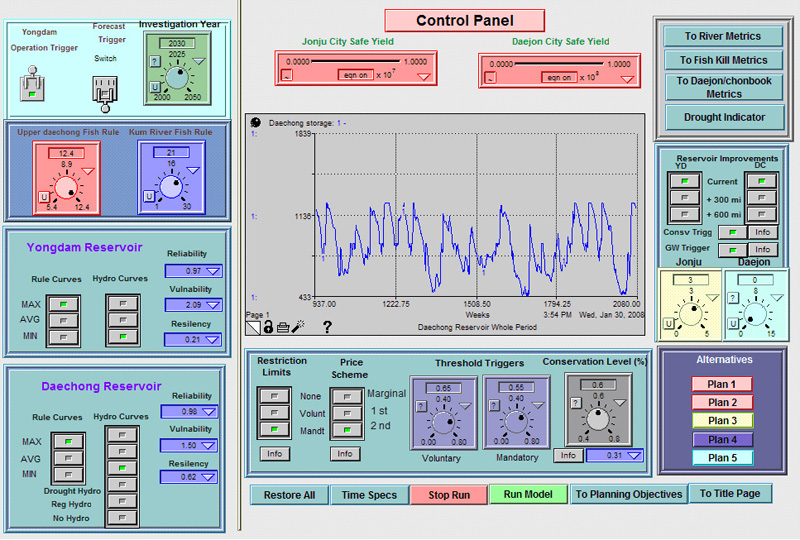
"Developing Water Conflict Negotiation Model"
Conflicts occur in water resources planning and management for a variety of reasons. Typical water conflicts can be classified into two basic categories: conflicts that involve consumptive uses that have clear economic benefits and conflicts that involve non-consumptive uses for which the economic benefits are not well defined. Control Panel of a Water Conflict Resolution Model
The classic upstream vs. downstream water conflict over the availability of water for out-of stream use is an example of the consumptive use category. The timing and volume of releases from a reservoir for environmental flows and the impacts of reservoir storage on recreation is an example of non-consumption water uses that may conflict. In this project, a decision support system was developed to resolve a classic water conflict between upstream and downstream users in a shared vision modeling framework. Conflict resolution procedures were identified and a range of acceptable management alternatives were provided. Working with stakeholders in a computer-aid negotiation setting, sustainable management strategies were also created to illustrate system trade-offs as well as long-term system planning.
Investigators:Richard Palmer, Sangman Jeong, Jae Ryu, Jooheon Lee
Funding Agency:Korea Ministry of Science and Technology
Relevant Publications:
(1). Jae H. Ryu, R. Palmer, S. Jeong, J. H. Lee, Y.-O. Kim, 2009. Sustainable Water Resources Management in a Conflict Resolution Framework, Journal of the American Water Resources Association, 45(2):485-499 [download]
(2). Ryu, J, Park, SK, Lee, KY. 2010. A Framework of Hydroclimate Modeling and Decision Support Tools for Sustainable Water Resources Planning in a Changing Climate. In 2010 World Water & Environmental Resources Congress, Environmental and Water Resources Institute, Providence, Rhode Island, May 16-20, 2010. [download]
(3). Ryu, J, Palmer, RN, Jeong, S, Lee J. 2004. Drought Definitions and Forecasts for Water Resources Management. In 2004 World Water & Environmental Resources Congress, Environmental and Water Resources Institute, Salt Lake City, Utah, June 27-July 1, 2004. [download] [Presentation File]
(4). Ryu, J, Palmer, RN, Jeong, S, Lee J. 2003. An optimization model to mitigate conflicts in the Geum River Basin, Korea. In 2003 World Water & Environmental Resources Congress, Environmental and Water Resources Institute, Philadelphia, PA, June 23-26, 2003. [download] [Presentation File]
(5). Palmer, RN, Ryu J., Jeong, S, Kim YO, 2002. An application of water conflict resolution in the Kum river basin, Korea. In: Proceedings of ASCE environmental and water resources Institute Conference, Roanoke, Virginia, May 2002, p. 19-22. [download] [Presentation File] -
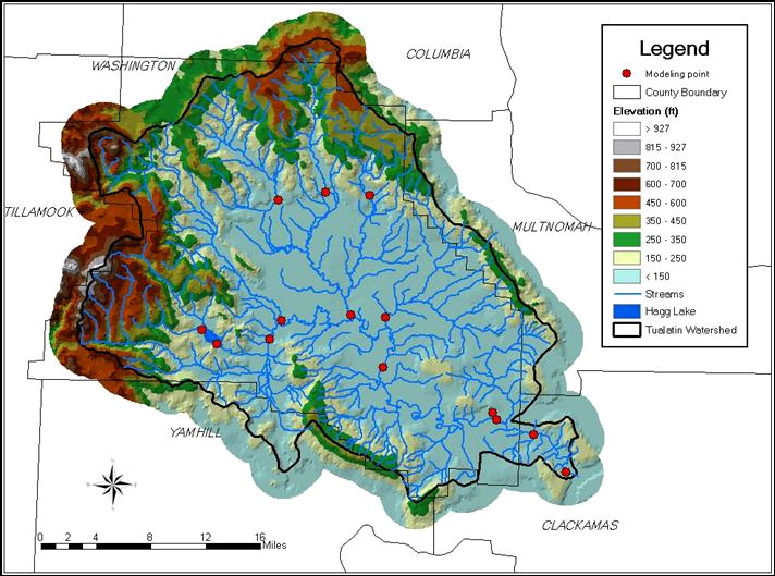
"Tualatin (Oregon) Climate Change Impacts Study"
The potential impacts of global climate change on the hydrology and future water availability in the Pacific Northwest is one of critical issues to sustain water supplies in the future.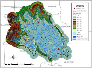 Delineated Tualatin Basin using ArcGIS
Climate-induced streamflow estimation, in particular, is an extremely important task in the sense that these new streamflows are used in a water resources model that is able to predict the future yield of water supplies. To identify the potential impact of climate change on water supplies in the Tualatin basin, a series of stuides has been done including 1) development of a hydrologic model and water resources model, 2) identification of time shift of spring snowmelt, 3) variability of precipitation and temperature, and 4) water demand outlooks associated with uncertain future climate. My role in this particular project was to develop a hydrologic model using GIS technology.
Investigators:Richard Palmer
Collaborators:Jae Ryu, Erin Clancy, Nathan VanRheenen, Matthew Wiley
Funding Agency:Clean Water Services -
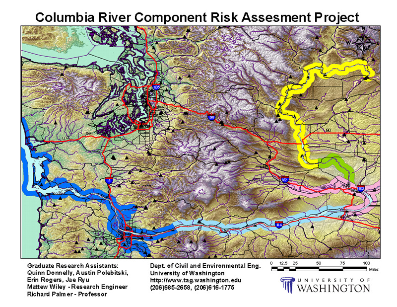
"Columbia River Risk Assessment Project"
The objectives of this research were to develop environmental database on the Columbia River, where nuclear byproducts were discharged from the Hanford Site back in the early 1940 during the Cold War. Bechtel Hanford, Inc. (BHI) was leading this project and working with five sub-contractors, including several regional universities. The University of Washington research team was in charge of collecting all pertinent information with Hanford Site-related contaminants in the assigned areas, and developing user interfaces using ArcGIS/ArcIMS and Google Earth for quick access to requested data. My role in this project was to identify potential areas where contaminants were dominated by the byproduct from Hanford Site, and to implement such infomation into the web using ArcIMS. Also, I have created a movie clip for fun.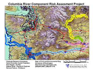 Columbia River Risk Assessment Project (ArcGIS)
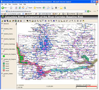 Web applications using ArcIMS
-
"King Abdullah Canal Water Quality Model"
The King Abdullah Canal is located in the Hasemite Kingdom of Jordan, which is the heart of the Middle East. The canal is a significant source of water for the country; however, its quality and quantity is dependent on the neighboring countries, as most of the water originates from either Israel or Syria. Recently, the King Abdullah Canal has had severe taste and odor problems due to eutrophication caused by excessive nutrient loading and associated algal blooms. A water quality model has been developed to identify the source of these problems and to evaluate the extent and cause of eutrophication. Additionally, total five water management alternatives were suggested to regulate algal growth so that the level of chlorophyll-a can reach to an acceptable level. Feasibility test as well as cost-benefit analysis have been done to find the best cost effective scenario.
Relevant Publications:
M. Brett, R. Palmer, Jae H. Ryu, 2002. Water Quality Simulation Model for the King Abdullah Canal in Jordan, A Project Report Prepared for CESAR from Dept. of Civil and Environmental Engineering, University of Washington [download]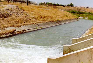 The King Abdullah Canal
-
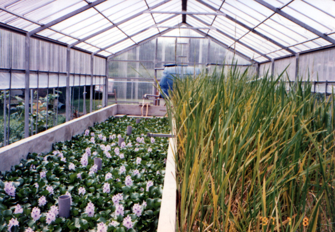
"Rural Wastewater Treatment using a Constructed Wetland"
An artificial wetland was constructed as a facility for wastewater treatment in rural areas. The pilot wetland system has well performed to lower conventional pollutants to acceptable levels. Water quality standards (e.g. BOD, SS, COD, and total coliform) were monitored, and design parameters of the wetland system, such as optimum loading rates and selective vegetation were recommended also. Constructed Wetland